The Empty Quarter - being a description of the Great South Desert of Arabia know as Rub’ al Khali
by Harold St John Bridger Philby, 1932
“. . . Arabia is still so little known to the world at large that it flatters the labours of any reasonably inquisitive visitor.”
An account, in Philby's words of a trip tracing his route undertaken from 8 Jan 1932 (last day of Shaban) - updated from 24 Nov 2003 (First day of Eid)
“I bundled myself out of the tent, barefoot, to range myself with the rest of my companions"
“… the mist, a good deal lighter than on the previous day, allowed a fairly clear view for several miles around”
“We resumed the march earlier than usual and ambitiously hoping to make Jabrin itself before nightfall”
“What a lifeless, desolate waste it was – and this vast plan was as bad as any part of it”
“About a couple of miles south east of the ruins of Qasr Umm al Ramad lies the simpler but better-preserved square building of Qasr Tuwairif, wholly constructed of salt-impregnated clay which seems to wear better than its crumbing appearance suggests. It is about 25 feet square each way but of no great interest”
We went to west of Jabrin, to tumuli, then south at the edge of the uplands and the sands. We failed to find both the wells at Qaliba and Al Uj.
After getting stuck in soft sand for over an hour towards the end of the day, we camped near Bir Ibn Juhayaim, again failing to find the well.
Getting demoralised about ever find a well, we joined a wide set of tracks, and came across Maqainama well (which was not on the Tactical Pilot Chart)!.
We realised now that Philby’s map was displaced in its longitude by at least 5 degress east, not unexpectedly since he only had a sextant (for latitude) and would have to calculate longitude by whatever chronometer he had and dead reckoning.
We then headed due east across the Ramla Maqainama
“Along the western fringe of the oasis I came upon three extensive groups of curious dry saline mounds”
“Our objective was Maqainama, and our marching was over a steppe country ‘the noses of Summan’”
“I was suffering agonies from the rough paces and sluggish gait of my camel”
“… we came to Qaliba, a single well of 10 fathoms in a wide bare depression in the midst of sandy downs”
(we failed to find the well)
“The sky was of an astonishingly brilliant shade of blue spotted here and there with wisps of white cloud as we resumed our march over a slightly undulating plain of flint and gravel.”
“The sandy floor of this tract soon gave way to gravel, and the baggage animals were sent straight ahead while my small party made a detour to visit the well of 'Uj, which we found about five miles on from our camp in one of the valleys descending from the Summan uplands. We came suddenly upon a basin of dirty, ruffled gypsum about half a mile across …”
“About mid-afternoon we came to them or rather to a firm, undulating sandy plain projecting from them towards the Summan; and from here onwards to Maqainama itself we marched, now on one and now on the other, along the sinuous boundary between the sands and the steppe. Here and there we passed by patches of exposed gypsum suggesting that the desert floor …”
“The gravel plain narrowed to a wasp-waist, beyond which it bulged out again into an oval strip of mixed gravel and sand with dunes on this side and that, those on the right and ahead actually impinging on and partly burying the border fringe of the Summan.”
“… a low ridge rose some 10 or 20 feet out of the plain with flattened top. 'Ali and Salih trotted forward from my side and dismounted at the foot of the barrow. We had reached Maqainama!”
“The bare sands and the bare steppe closed round us and we seemed to camp in an abomination of desolation, littered far and wide with date stones from Jabrin, the residue of Badawin meals.”
“We loaded up and marched away from Maqainama without regret, but with the first serious item of our programme duly accomplished. The next objective was Wabar.”
The Ramal Maqainama were large bare dunes with sinuous gravel rivers. We had to snake between and over, before coming to a large gravel plain, more dunes, then a sequence of dunes and gravel bands (all having many tracks north/south).
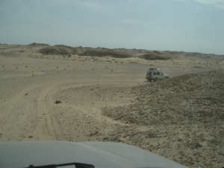
The highlight was meeting up with 2 friendly camel riders herding a train of dark camels, coming out of the horizon like a mirage.
The dune/gravel changes are the same as Philby mapped over 70 years ago!
After Bir Fadhil well we turn south, but got sanded so camped before Shalfa. Philby named the area ‘Shalfa’ (Arabic for spearpoints) after finding flints – now Shalfa is the name of a small station with iffy petrol though there was some for us
“… through the downs of Ramla Maqainama. A fair wind blew upon from the south and the gap gradually widened between us and the long, dark line of the Summan until it disappeared from our view and left us engulfed in an ocean of sand.”
“… the eastern extremity of Ramla Maqainama overlooking another broad gravel strip-Hidba Buraika”
(lunch in the middle of a gravel plain)
(The camel herders)
“… traversing Buraika (over the gravel to sands), Hawiya (over sands with much Ghadha to gravel) and finally into the pastures of Madara…”
"… where we camped before 4 p.m. as the atmosphere, now warm and still, had induced somnolence all round.”
“On the third day (January 28th) out from Maqainama we reached Bir Fadhil after quite a short march… about two miles short of the wells, we entered real dune country-a stormy sea of lofty billows tossed here and there in disorder but generally facing north with a rolling crest or incipient horseshoe hollows.
“Once we had to descend a very steep slope of soft sand, while a strong blustering south wind blew about us till 5 p.m. when it dropped, leaving us to enjoy a clear, soft, warm night.”
“At Bir Fadhil we found four wells spread over a mile length in a wide depression of the sands. The original shaft was out of action and half filled with sand as the result of a visit in the preceding April by a raiding party of the Sa'ar tribe.”
“They had watered their animals and filled their skins but had not troubled to replace the usual cover. I cast a stone into its depths but there was no answering sound of water”
"I, therefore, insisted on proceeding southward rather than in the direction suggested by my guide. That was accordingly the direction in which we struck out next morning after watering the camels, filling up our 32 waterskins with the last sweet water we should see for some time-that of Bir Fadhil ranks high in Badawin estimation though doubtless similar to the water of Maqainama-and replacing the cover over the mouth of the well.”
“At 10 a.m. a fresh south wind was blowing as we marched along a range of dunes, whose half-formed horseshoe hollows faced northwest below their sharply chiselled wall-like crests.”
“From Bir Fadhil onwards, I had supposed, all would be sand and nothing but sand. But that was far from being the case. Between it and Tuwairifa greater or smaller gravel patches and exposures of the underlying bedrock were pleasingly frequent. Clearly, therefore, the western (waterless) part of the Rub' al Khali was less sandy than the eastern, while here in Shuqqat al Khalfat we had a gravel plain some 10 miles long, as far as I could judge, and three miles broad.”
“Between the parallel dune-ranges lay shallow sandy valleys with frequent patches of the bedrock exposed and sprinkled with gravel. My companions indeed seemed to resent my frequent detours to visit them, though they showed every sign of satisfaction when one such patch, larger than most, yielded a harvest of flints in the gravel over lying a soil of markedly alluvial character.
We celebrated the circumstance by naming the valley Raqqat al Shalfa. (The beach of the spearpoint).
(Shalfa as it is now)
We continued fast south to the Tuwairifa wells, easily found from a known waypoint.
Then due east to Wabar across rows of north/south dune lines with sandy valleys between. The challenge was crossing the valleys without getting stuck, then finding a saddle and slip face that didn’t descend into soft sand.
Again the waypoints of the dune lines matches Philby’s map!
This took much longer than we expected, so we camped. The next day the way to Wabar was open sand with no more dune ranges.
“The five wells of Tuwairifa lie in a sandy hollow with a dune range some 40 or 50 feet high running along the north side of the valley. The main well is, however, clearly traceable, while the others were not difficult to locate by exposed portions of their raised lips and the usual litter of debris cleared from the shafts-at the bottom of one of which, they told me, lies the corpse of a man who was entombed years ago by the collapse of the shaft while he was engaged in clearing it out.”
“Before us lay the vast expanse of Bani Mukassar, a tract of several long parallel dune ranges. We seemed now to be in the very midst of the Great South Desert and the short lengths of dunes we had seen amidst the lower sands hitherto now gave way abruptly to dune barriers mountainous by comparison. Between the first two ranges lay a broad valley of rolling sand with considerable patches of the gritty or pebble-strewn rock floor exposed.”
“…. the wind swept the sand in a continuous sheet from its crest …”
“It differed from the preceding tract in being an ocean of sand billows frequently streaked with short ranges of higher dunes like the breakers of a reef-strewn sea. The dune ranges, instead of being long and continuous, were long but broken up into short echeloned lengths; and our course ran through no fewer than 10 of these intermittent ranges until we emerged on an upland of sandy downs without any dune features to break its ocean-like regularity.
“… and it was 5 p.m. before we came up with the baggage party just as it had selected a site for the evening's camp after twelve hours of almost unbroken marching.”
“For half an hour we marched on over the desolate sands, rather wearily for the wind had gone round again to the south and it was a sultry afternoon. Look! exclaimed' Ali suddenly, and I had my first glimpse of Wabar-a thin low line of ruins riding upon a wave of the yellow sands”


"I reached the summit and in that moment fathomed the legend of Wabar. I looked down not upon the ruins of an ancient city but into the mouth of a volcano, whose twin craters, half filled with drifted sand, lay side by side surrounded by slag and lava outpoured from the bowels of the earth. That at any rate was the impression that flashed through my mind in that moment. I knew not whether to laugh or cry, but I was strangely fascinated by a scene that had shattered the dreams of years. So that was Wabar! A volcano in the desert! and on it built the story of a city destroyed by fire from heaven for the sins of its King, who had heeded not the warnings of the prophet Hud-generally identified with the biblical Heber-and had waxed wanton with his horses and eunuchs and concubines in an earthly paradise until the wrath came upon him with the west wind and reduced the scene of his riotous pleasure to ashes and desolation!”

“Many of my companions were already on the scene, burrowing in the debris for treasure. As I descended the slope towards the first crater, they came running up to me with lumps of slag and tiny fragments of rusted iron and small shining black pellets, which they took to be the pearls of 'Ad's ladies blackened in the conflagration that had consumed them with their lord.”
"Thus in a couple of hours I had gained a fairly complete impression of all there was to see at Wabar, although I left the actual mapping of the area to a later occasion. I had also collected a fairly wide range of specimens of the slag and other debris ranging from pieces the size of a man's head to little bombs of fused stuff and the still smaller pearls.”
“Continuing our march now in an ENE direction. …”
“… we passed on over the bare downs to Umm al Hadid only two miles distant to the north-north-west. In an extensive depression of sand with a litter of gravel in parts the three wells are situated at the points of a small equilateral triangle. All were now equally dead though not entirely buried, for their mouths stood out prominently from the sand with a showing of rock and stratified masses of camel dung hardened by age.”
“In due course we arrived before a charming, fairly extensive, oval patch of gravel-like a lake surrounded by the rolling, bush-covered downs of sand-in which lay the wells of Ibrahima with our camels in a group by the side of the most southerly shaft, which had been opened up by Suwid and the two herdsmen for their refreshment.”
(Philby now continued south across the Empty Quarter. We went north to Ubayla and Nadqan and to rejoin the Harad road)